Village of Stokeford in 1930 and 2010 - IELTS Writing Task 1 Map
Go through the sample answer and report plan for the IELTS Writing Task 1 Map topic: Village of Stokeford in 1930 and 2010. This will assist you in crafting your own responses for IELTS Writing Task 1 questions.
Table of Contents
Limited-Time Offer : Access a FREE 10-Day IELTS Study Plan!
In the IELTS Writing task 1 Academic section, you’ll encounter a visual representation or diagram that requires you to write a descriptive paragraph. One possible type of visual is a map, which will show the same area at two different points in time. You'll need to identify and explain the transformations depicted in the maps provided.
Here is a sample IELTS Map Diagram question and answer to help you prepare for similar tasks and achieve a higher IELTS band score in the IELTS Writing exam.
Want to master IELTS Writing Task 1? Check out our comprehensive guide to understand the structure and boost your IELTS writing skills!
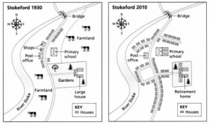
The maps below show the village of Stokeford in 1930 and 2010.
You should spend about 20 minutes on this task.
Summarise the information by selecting and reporting the main features, and make comparisons where relevant.
Write at least 150 words.
Village of Stokeford in 1930 and 2010 - IELTS Writing Task 1 Map Report Plan
Paraphrase: Paraphrase the topic sentence.
Overview: Mention the main features of the given map and give an overview of the main differences between the two maps.
Paragraph 1: Make comparisons between the two maps.
Paragraph 2: Make comparisons between the two maps.
Master IELTS Writing in 10 Days Download Free Study Plan
Village of Stokeford in 1930 and 2010 - IELTS Writing Task 1 Map Sample Answer
The given maps show us the changes that have taken place in the village of Stokeford in 2010 compared to the locality in 1930.
There have been quite a few major changes in the outlook of the village over the years. It is also noticeable that there were more residential buildings in Stokeford in 2010 than in 1930.
A major part of the area of Stokeford was used for agriculture and farming in 1930. There were a few shops and a post office towards the northern end of the village, along with a bridge over River Stoke. There was also a primary school in the village and a large residential compound.
By 2010, the village had transformed into a residential area from an agricultural area. Most of the farming area and the market area were used to build houses. The primary school was also renovated into a larger building. The compound with a large house was transformed into a retirement house. However, the bridge and the post office were unchanged.
Register for an IELTS Expert Session today & gain expert advice to excel in IELTS Writing Task 1!
Also check:
- IELTS Writing Task 1 Bar chart
- IELTS Writing task 1 tips
- Tips to Improve IELTS Writing Skills
- IELTS Writing recent actual test
- IELTS Writing Answer sheet
- IELTS map vocabulary
- IELTS Writing Task 1 Connectors
Practice IELTS Writing Task 1 based on report types
Start Preparing for IELTS: Get Your 10-Day Study Plan Today!
Explore other sample Map Diagrams

Nehasri Ravishenbagam

Kasturika Samanta
Nehasri Ravishenbagam
Recent Articles
Kasturika Samanta
Janice Thompson

Janice Thompson




Post your Comments
2 Comments